WEDNESDAY 21 September
(There are 13 photos in this post, all shot on a Google Pixel 6 Pro. As always, they are captioned and distributed throughout the text. )
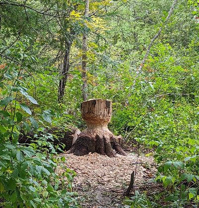
We did not see the beavers on our short, ~1/4-mile, hike to the Moss Glen Falls, but we did see this evidence of their handiwork at felling trees. The park service dropped the tree to prevent it from becoming a hazard to visitors.
I stayed up last night to publish a couple of blog posts, and did not get to bed until 1 AM. Nevertheless, I was up at 7 AM, did my morning chores, and heated the water for coffee. I was quiet, as always, and Linda got up at 7:45. We nowhere we had to be during the morning, and I would have slept longer if I could.
With no blog posts to work I, worked a few Pic-a-Pix puzzles on m iPad. Small, easy ones at first, and then a larger and more difficult B&W one. We try to keep up with updates for our devices and I had another nine for my phone. Two apps wouldn’t update (Android System Intelligence and Private Compute Services). Both apps were Android components from Google, and the list of things to try resolving the problem was annoyingly long. We really liked our Google Pixel 2 / 2XL phones, and we have really liked our Google Pixel 6 / 6 Pro phones so far, especially the camera and image processing, but this kind of thing is just plain annoying and, frankly, stupid for a customer to have to deal with. Arrrgh.
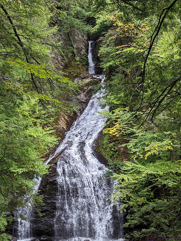
We had to hike/climb up to the designated viewpoint to actually see the waterfall. This is most of it. Safety ropes and signs prevented getting a slightly better shot. The overcast day actually made for a soft light with less contrast; excellent for shooting in deep woods.
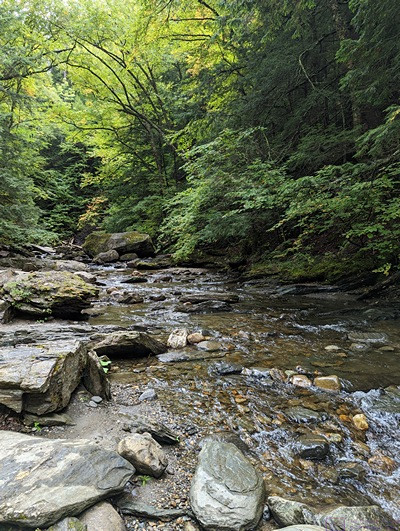
This is a view, looking upstream, of the river that flows away from the bottom of the Moss Glen Falls. There is a beaver pond nearby, so I suspect that not all of the water from the falls is flowing out on this river.
We had bagels for breakfast (with butter and cream cheese) and fresh fruit (bananas, black raspberries, and strawberries), with some orange juice. On a recent walk around the campground, we were able to chat with one of the three people who work here (and probably own it). We mentioned how empty it was on Monday and Tuesday. He assured us it was very busy all summer, would be busy again by the weekend, and in another week or so, when the fall colors finally appear for real, it will be full.
We finally got a neighbor on our driver/left side this morning, which seemed odd at first as it was way before the 1 PM check-in time. We chatted with the them briefly before leaving for the day. It turned out that they were already in the campground yesterday but decided to extend their stay through Thursday night, which resulted in them having to move to a different site. They were from S. Carolina and were driving a 2008 Winnebago Destination but did have a “toad.” It turned out that they were traveling with friends, who were parked about 10 sites down and were towing a car behind their motorhome.
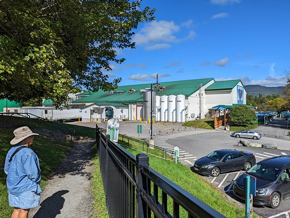
The view of most of the Ben & Jerry’s factory building in Waterbury, Vermont as we walked down from the guest parking area.
Our first destination today was Moss Glen Falls. The Falls trailhead was approximately a mile east of VT-100, about 5 miles north of Stowe, Vermont. Most of the road after leaving VT-100 was gravel. Just before reaching the trailhead parking lot, the road was being worked on and was down to one lane. The construction zone was only about 30 feet long, so the workers also acted as traffic control. The parking lot was small, and about 70% full, but I had no trouble finding a spot.
The trail to the Falls was ~1/4 mile, with almost no elevation change until the end. It followed the river from the outflow of the Falls, but also traversed a lot of marshy area. A very nice system of boardwalks kept our feet dry. The area had an active beaver population, and while we did not see them, we did see evidence of their tree felling activities. Towards the end of the trail, we had to hike up about 75 feet to get to the viewing area for the Falls, which drop about 125 feet.
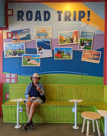
Linda finishes her non-dairy ice cream cone at Ben & Jerry’s factory ice cream shop. The ‘Road Trip’ background seemed appropriate.
Our visit to Moss Glen Falls concluded, we headed back towards Stowe to pick up VT-108 to Jeffersonville via Smuggler’s Notch and Smuggler’s Notch State Park. As we were coming into Stowe we saw a sign for VT-108 and turned. A short distance later, we had to make a decision to turn left or right. We went right and almost immediately were on a gravel road. We were supposed to be on the main road to the ski resorts west of Stowe, and my instincts told me this could not possibly be that road, which is open all winter and sees a lot of traffic. Still, It took us a few miles to figure out (convince ourselves) that we were not where we had intended to be.
We doubled back to the intersection where we had turned the wrong way, and thought we were now on track, but soon realized we were still not back on VT-108. Linda was navigating on her phone by this point, and could see that we were at least on a track that would eventually lead us to VT-108. Besides, we got to drive somewhere we hadn’t planned to visit, and see nice mountain side homes on large properties. Some days are like that. (Stowe is a small, but upscale iconic Vermont village, and driving around in a residential area of the mountains underscored that there was a lot of money in here.)
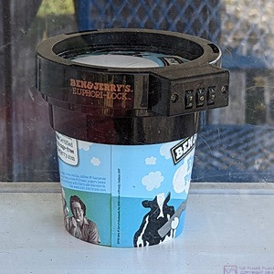
The main gift shop at the Ben & Jerry’s factory is only available to guests who have taken the factory tour (they exit through the gift shop). There was a small gift shop outside, however, for anyone who wandered in, especially those (like us) who just came for the ice cream shop. I know the Ben & Jerry’s ice cream is pretty good stuff (it’s the number one ice cream brand in the U.S.) but I was amused by this combination lock collar that you can (apparently) buy to secure your pint against unauthorized use.
VT-108 is the road to the well-known Stowe, Vermont ski area. As expected, the road was in excellent condition. As we climbed up towards the base of the ski slopes, we saw more and more, and nicer and nicer, B&B’s, Inns, Lodges, Resorts, and vacation homes, as well as the ski slopes and lifts. Mount Mansfield, at 4,393 feet AMSL, is the tallest mountain in Vermont and anchored the Stowe Mountain Resort.
All of that was nice, and interesting of course, but the main reason for coming up here was to drive through Smuggler’s Notch and the State Park that encompasses it. Megan and Scott, from Timberland CG in Shelburne, New Hampshire, had strongly recommended that we do this drive; and they were right. At 2,162 feet AMSL, Smuggler’s Notch is not the highest auto-drivable road in the State. That honor belongs to the Lincoln Gap, at 2,424 feet AMSL, between Lincoln and Warren, Vermont. But that road is not open in the winter, whereas VT-108 is open year-round. And Lincoln Gap is not Smuggler’s Notch.
From: www.vermont.com/cities/smugglers-notch/
“Smugglers’ Notch, Vermont is a mountain pass located in Lamoille County. The notch separates Mount Mansfield, Vermont’s highest peak, from Spruce Peak and Sterling Ridge. Some locals refer to the area as “the quiet side of the Mountain,” and the road through the notch, Route 108, is one of two officially designated scenic highways in the state.”
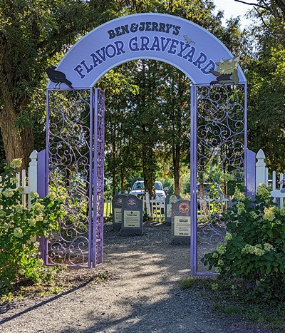
The entrance to the Ben & Jerry’s “Flavor Graveyard.” A few of the “headstones” are visible through the entrance.
It was an amazing road through the notch, and the scenery was also amazing. The sun had come out and there were just enough clouds to be interesting, with some still hanging around the peaks of the mountains. The road was narrow often barely one lane wide, with no shoulder and with tight hairpin turns, some of which had huge boulders on the inside of the curve and a sheer rock face on the outside of the curve.
In fact, this stretch of VT-108 is length restricted; fixed wheelbase vehicles cannot exceed 40 feet, and articulated vehicles cannot exceed 45 feet. And there are hefty fines if you ignore these limits and get caught. (If you get stuck, the fine is $2,400, but having driven it, I wouldn’t take a fixed wheelbase vehicle over 25’, or a travel trailer of any kind or size, through the notch). Alas, all of the places to pull off the road or park were taken, so we just drove through. But that was OK; we enjoy a nice scenic drive, and this was one of only two designated scenic roads in all of Vermont.
VT-108 intersected VT-15 in Jeffersonville and we took it east towards Johnson and on to Morristown to pick up VT-100 south back to camp. There was a truck route to bypass downtown Morristown, but we stayed with the main route as we wanted to see downtown. Morristown was actually fairly large, and VT-100 wound through what seemed like three separate downtown area. (This was another example where we “be a truck” if we had been towing the trailer.)
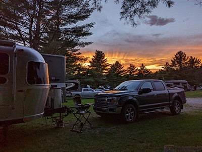
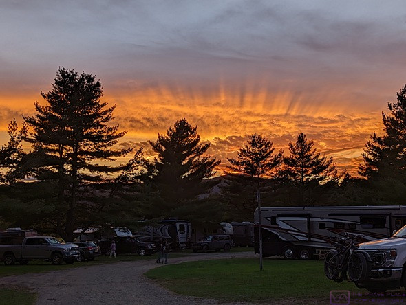
The setting sun illuminated the underside of a cloud layer and lit up the sky like it was on fire. Our truck and the front part of our trailer in the foreground. I wasn’t the only one who noticed this; somewhere between 6 and 12 RVers were also trying to photograph this.
Coming back into Stowe from Morristown, we saw the same sign for VT-108, but this time was also saw the “ALT” on the sign. “ALT” makes all difference. Going through downtown Stowe, we finally saw were VT-108 actually came off of VT-100.
As we were getting close to our campground, we decided to keep going and visit the Ben & Jerry’s Ice Cream factory in Waterbury. We had been there before, but it was a long time ago. Reservations were needed to tour the factory, but we did not feel the need to do that again. What we wanted, and what we got, were ice cream cones. We sometimes have non-dairy ice cream at home, and have had it in the trailer a few times on this trip, but actually going out and getting an ice cream cone was a rare treat.
We got in line at the Ice Cream Shop and waited 20 – 30 minutes before ordering. They currently make 18 different non-dairy “frozen desserts” but the only one available at the window was “Colin Kaepernick’s Change the Whirled.” We wanted waffle cones, but they weren’t vegan ☹ The sugar cones were, however, so we each one ?
Most of their non-dairy products were made from almond milk, but the “Colin Kaepernick’s Change the Whirled” was one of only four that was made from “Sunflower Butter.” We had never heard of this but, based on our experience, it was the best non-dairy “ice cream” we had ever had.
We had just finished our treats when we ran into our neighbors from the campground and their traveling companions, and chatted with them for a bit. They had made a day of visiting the Cold Hollow Cider Mill, Lake Champlain Chocolates, and a few other places between Stowe and Waterbury. Ben ^ Jerry’s was their final stop for the day. We then visited the “Graveyard of Retired Flavors” on our way back to our truck. Set up like a cemetery, each retired (discontinued) product had its own “headstone” with a clever inscription (as some headstones are want to have) and the first and last year of production (as all headstones have). A few of them had been “resurrected” and then retired again (something not seen on most headstones). One had been in and then out of production three times.
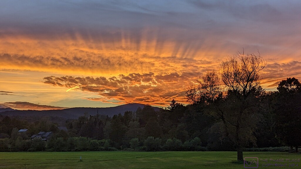
This sunset went on for a long time and, as sometimes happens, just kept getting better until it was suddenly done. (This photo is 1198 by 674 pixels; click to view full size.)
Back in camp, Linda e-mailed Revolution Kitchen in Burlington to see if we could get a reservation for 5 PM tomorrow. Her request was answered in the affirmative, so our plans for tomorrow fell into place. I copied photos from my phone to my laptop computer and started working on this blog post. We were eventually hungry enough for dinner and got the WeberQ grill out of the truck. Linda grilled the vegan kielbasa and roasted some mixed fingerling potatoes on the grill, and heated up some sauerkraut in the microwave oven. We had Barefoot Riesling wine with our meal and piece of chocolate for dessert.
Linda needed an S.O.S. pad to clean the roasting basket and I suggested we drive up to the Shaw’s in Stowe. I noticed some nice color in the western sky, but when I looked closer I found an amazing sunset in progress over the mountains. I grabbed my phone to get pictures, and I wasn’t alone. At least a half-dozen other campers had come out to do the same thing. Pictures taken, we loaded the grill back into the bed of the truck and headed off to Shaw’s on the north end of Stowe.
PHOTO – PXL … stitchh4_1680x404_sunset-1 … This is a composite of four images. (It’s 1680 by 404 pixels; click to enlarge.)
The Stowe’s Shaw’s was not nearly as large, or as nice, as the one on the north end of Waterbury, but it had what we needed, and more. We always go up and down the isles in a new-to-us supermarket, and we inevitably find things to buy.
It was dark by the time we got back to the campground, and I mean really dark. The entrance sign F-150 navigation screen. We had also driven this road enough by this point that I knew where it was.
No TV tonight; just reading and writing and photo editing and puzzle playing. I got this post mostly written, and the photos selected and edited, but did not get them placed and captioned. I hope to get that done in the morning before we head out for the day. The weather forecast was calling for rain overnight and into tomorrow, with the possibility of thunderstorms after 1 AM. The temperature was predicted to hover around 60 (F) until 4 PM and then fall to 43 (F) by 8 AM on Friday. Before heading to bed, I checked that all of the windows in the truck where closed and that the windows and exhaust fan vents were closed in the trailer. The sky was dark and clear, the only light pollution coming from the exterior lighting on many of the RVs. Both the Big and Little Dipper constellations were visible, which is often not true for the Little Dipper, as was the Milky Way. Not bright, but clearly and distinctly there. This was only the 3rd or 4th time during our entire trip (to-date) that I have seen the sky this dark and clear.
…
